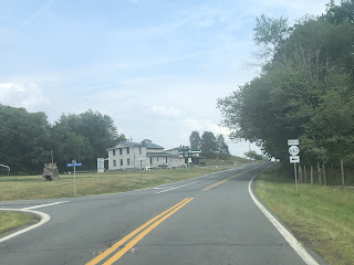
Virginia State Route 230 is a state route that goes from Business US 33 in Stanardsville to US 15 just north of Orange.
 |
| VA-230 Shield |
The Route Path:
VA-230 starts at Business US 33 in Stanardsville, the county seat of Greene County. The route goes north, eventually leaving the town limits and turning into a rural highway. VA-230 intersects multiple secondary routes, including SR-667, providing access to the northernmost parts of the county. Just after the intersection with SR-667, the route crosses the Conway River and enters Madison County.
 |
| VA-230 leaving Stanardsville. |
VA-230 continues through rural forested areas as it approaches the unincorporated community of Hood. After going through Hood, the route turns to the east and goes toward Wolftown, where it intersects and goes on a short concurrency with SR-662, which goes to Graves Mill and Shelby.
 |
| VA-230 at the western SR-662 intersection in Wolftown. |
The route stays east going through farmlands of Madison County, before reaching US 29, and heading north on a concurrency with it. Less than a mile later, VA-230 splits from US 29, and joins VA-231 on its way east of US 29. That concurrency also lasts less than a mile, before VA-231 splits to go to Gordonsville. VA-230 continues east, in a near straight line.
The route passes through Aroda, Radiant, and Burnt Tree before returning to farmland and reaching US 15, where the east end of VA-230 is located.
My Experiences:
I have been on VA-230 many times, as I used to live not far from the route in late 2021. I have also clinched the entire route, with the final part being traveled on 5/21/23.


