Search Routes

Showing posts with label US Route. Show all posts

US 250

 US Route 250 is a road that goes from US 6 in Sandusky, Ohio to US 360 in Richmond, Virginia. Since this is a Virginia-based website, this page will only have the eastern part of the route in Virginia.

The route east of Staunton mainly serves as a local route to I-64, while serving as the main route to Highland County and points west on the other side of Staunton.

US 250 Shield

US 21

US Route 21 is a road that goes from I-81, and US 52 in Wytheville, VA to Hunting Island State Park in South Carolina. Since this is a Virginia-based website, this page will only have the northern part of the route in Virginia.

US 21 Shield

US 219

 US Route 219 is a road that goes from I-90 in West Seneca, NY to US 460 in Rich Creek, VA. Since this is a Virginia-based website, this page will only have the southernmost part of the route in Virginia.

The route is only about 1.75 miles long in the state, but connects the town of Rich Creek and US 460 to the town of Peterstown, WV.

US 219 Shield

US 29

 US Route 29 is a road that goes from MD-99 in Ellicott City, MD to US 90/98 in Pensacola, FL. Since this is a Virginia based website, this page will only have the Virginia part of the route.

In Virginia, US 29 is mostly a 4-8 lane divided highway, and is a major corridor. It's also an alternative for I-81 and I-95. Parts of the route in Amherst/Nelson and Madison Counties can be very scenic.

US 29 Shield

US 23

 US 23 is a road that goes from I-75 in Mackinaw City, MI, to US 1 in Jacksonville, FL. Since this is a Virginia based website, this page will only have the part of US 23 in Virginia.

US 23 Shield

US 522

 US Route 522 is a road that goes from US 11/US 15 in Selinsgrove, PA to US 60 in Powhatan, VA. Since this is currently only a Virginia website, I will only do the Virginia part of the route.

US 522 Shield

US 501

US Route 501 is a road that goes from US 60 in Buena Vista, VA to US 17 in Myrtle Beach, SC. Since this is currently a Virginia based website, this page will only have the Virginia part of the route.

US 501 Shield

US 48

 US 48 is a road that goes from I-79 east of Weston, WV, to I-81 just north of Strasburg. But since this is a Virginia based website, only the Virginia portion will be here. The route is concurrent with VA-55 the entire length.

US 48 Shield

US 258

 US 258 is a road that goes from VA-143 at Fort Monroe in Hampton to Business US 17 in Jacksonville, NC. Since this is a Virginia-based website, only the Virginia portion will be here.

US 258 Shield

Fort Monroe to Smithfield:

US 311

 US 311 goes from Business US 58 just west of Danville to US 52 and NC-8 in Winston-Salem, NC. But since this is a Virginia-based website, this page is only going to have the short portion in Virginia.

US 311 Shield

US 33

 US 33 is a road that goes from US 20 in Elkhart, Indiana, to US 1, US 301, and VA-33 in Richmond. But since this is a Virginia-based website, this page will only have the Virginia portion of US 33.

US 33 Shield


The Route Path:

US 33 enters Virginia on Shenandoah Mountain. After entering the commonwealth, the route goes down Shenandoah Mountain, passes by Switzer Lake, and heads toward Rawley Springs. About 11 miles later, US 33 reaches Rawley Springs, though it only passes by it.

After passing by Rawley Springs, the route passes through rural western Rockingham County. Just over 5 miles later, US 33 passes through Hinton, and continues its rural course before reaching Dale Enterprise. After that, the route becomes more suburban and widens to 4 lanes as it approaches Harrisonburg. 

US 33 passes through Western Harrisonburg until it gets to downtown and meets VA-42, where US 33 drops to 2 lanes. A couple blocks later, US 33 gets to Court Square, where both directions of US 33 split. The eastbound lanes turn left and meet US 11 east of the Rockingham County Courthouse. East US 33 goes concurrent with North US 11, while it’s the opposite for West US 33 and South US 11. Just after the concurrency starts, it ends and US 33 is reunited.

A couple blocks later, US 33 widens to 4 lanes again. It runs through eastern Harrisonburg, about 1.3 miles later, US 33 meets I-81, and the route continues through heavily commercialized areas as 6 lanes. After finally leaving Harrisonburg, US 33 goes back to 4 lanes. The route goes through slightly suburban central Rockingham County.

About 2.25 miles later, US 33 meets VA-276 and goes through Penn Laird. Shortly after, the route meets SR-996, which provides access to McGaheysville. A little bit later, US 33 runs just to the north of McGaheysville. Almost 5 miles after, Business US 33 splits off to go into Elkton. US 33 bypasses Elkton to the south, and has a freeway exit for US 340, which is where US 33 reunites with it’s business route.

US 33 East approaching SR-981 in Rockingham County.

After Elkton, US 33 runs by some of the Blue Ridge Mountains as it approaches them, which happens after 4 miles, and the route reduces to 3 lanes. US 33 climbs up the Blue Ridge Mountains, where it has a small interchange with Skyline Drive at the top.

US 33 West at its junction with Skyline Drive.

After the interchange, the route heads back down the mountains as it enters Greene County. After leaving Shenandoah National Park, US 33 approaches Lydia and reduces to 2 lanes. After going by Lydia, the route continues down the mountains, where it widens up to 4 lanes and intersects SR-810.

US 33 widening to 4 lanes west of SR-810 in Greene County.

Shortly after, Business US 33 splits off for Stanardsville, while US 33 bypasses it to the south. After 2 miles, the routes reunite, and US 33 heads southeast through rural Greene County. It intersects SR-633 in Quinque, before reaching Ruckersville, where the route intersects US 29 and shrinks to 2 lanes.

US 33 leaving Ruckersville.

US 33 Westbound approaching Ruckersville, during some construction.

US 33 continues through rural Greene County, before entering Orange County after about 2 miles. Shortly after, the route reaches Eheart. After about 3 miles, US 33 gets to Barboursville, where it intersects and goes on a concurrency with VA-20.

US 33 intersecting SR-644 in Eheart.

US 33 approaching the VA-20 concurrency.

After the concurrency, US 33 goes through the Southwest Mountains. Shortly after leaving them, the route reaches Gordonsville, where it goes on a short concurrency with VA-231, that concurrency ends at a roundabout with US 15, which US 33 runs concurrent with through Downtown Gordonsville.
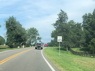

US 33 approaching Gordonsville.

US 33 entering Gordonsville just west of VA-231.

US 33 and VA-231 approaching the Gordonsville Roundabout.

US 33 concurrent with US 15 in Downtown Gordonsville.

Just southeast of Gordonsville, the route splits from US 15. US 33 goes through rural Louisa County, until it reaches VA-22 in Trevilians, where the routes go onto a concurrency until they get to Louisa, where they pick up VA-208, but US 33 leaves the concurrency after a couple blocks.

US 33, VA-22, and VA-208 in Louisa

US 33 heads southeast for a few miles, before reaching US 522, which it goes concurrent with for less than a mile, and US 33 continues eastward. The route continues throughout rural Louisa and Hanover Counties until it reaches Montpelier, where VA-54 meets its west end.

US 33 East of US 522

After VA-54, US 33 stays rural until it reaches the Henrico County line, where it widens to 4 lanes and has an interchange with I-295. US 33 continues through the Richmond Suburbs, where it meets Hungary Road and later, Parham Road.

In Dumbarton, US 33 meets VA-356. It also meets Dumbarton Road before having an interchange with I-64. US 33 continues after I-64, and enters the City of Richmond right before reaching US 250.

US 33 and US 250 run concurrent east through Richmond, and shortly after meeting, they have an intersection with VA-197 and an indirect interchange with I-195. Shortly after, they meet VA-161, and continue to approach Downtown Richmond.

Once the routes reach US 1 and US 301, US 33 splits off, while US 250 continues east. Just south of I-64/95, US 33 breaks off of the concurrency, and heads east through Northern Downtown Richmond, the route goes over I-95 on Leigh Street Viaduct, and meets VA-33 at the end of the viaduct, which is also the end of US 33.

My Experiences:

I have been on US 33 countless times, due to it being the closest US route from me. It is most likely in my top 3 most used routes all-time.

US 211

 US 211 is an intrastate US Route in Virginia that runs from I-81 in New Market to Business US 15/29 in Warrenton. It connects Warrenton and Northern Virginia with Luray and New Market.

US 211 Shield

The Route Path:

US 211 begins at I-81 just west of New Market, right after beginning, the route reaches US 11, and both go concurrent for a couple of blocks, then US 211 leaves US 11 to go up Massanutten Mountain.

Looking east from the western beginning of US 211.

This is at the southern end of the US 211/US 11 concurrency.

US 211 and US 11 both head north for a couple of blocks in New Market.

US 211 EB splitting from US 11.

After going past a few houses, US 211 expands into a 4 lane divided highway. That doesn’t last long, since the route shrinks to 3 lanes once it starts to climb Massanutten Mountain. After some climbing, US 211 reaches New Market Gap, and begins going back down. Just after returning from the mountain, the route expands back to a 4 lane divided highway and intersects US 340.


The first eastbound distance sign on US 211.

The route shrinks into a 3 lane undivided highway before climbing up Massanutten Mountain.

Entering Page County from Shenandoah County.

The west end of the US 340 concurrency.

Both routes head concurrently through rural Page County, before passing by the Luray Caverns Airport and meet Business US 211. Both US 211/340 bypass the town on a semi-freeway. Halfway through the bypass, US 340 splits from US 211, which is also Business US 340’s northern end. East of Luray, Business US 211 meets the mainline route again.

After Luray, US 211 heads east towards the Blue Ridge Mountains, shrinking to 3 lanes as it starts going up. While going up the Blue Ridge Mountains, the route enters Shenandoah National Park. At the top of Thornton Gap, US 211 meets Skyline Drive, and goes back down.

Once the route gets to a slower descent, it reduces to 2 lanes and heads toward Sperryville. Once at the bottom of the mountain, Main Street begins and heads to Downtown Sperryville. Leaving Sperryville, US 522 joins US 211 and widens to 4 lanes shortly after.

US 211 is concurrent with US 522 in western Rappahannock County.

The route(s) widen to a 4 lane divided highway after leaving Sperryville.

About 4 miles later, Business US 211 splits off to go to Washington (VA). Both US Routes bypass the small town, meeting the business route just to the northeast. Both routes continue through rural Rappahannock County, until US 522 splits off from US 211. The route then passes by Amissville and into Culpeper County.

Almost 3 miles later, US 211 meets the northern end of VA-229. the route continues east into Fauquier County. After passing through rural areas of the county, US 211 reaches Warrenton, before intersecting Business US 29/15/17 and heading northward with them, while Business US 211 continues straight. All routes go through Warrenton, and about 2,000 feet from Mainline US 29/15/17, both US 211 and its business route meet their end.

My Experiences:

I have only been on US 211 about four times, including October 13, 2023, when I used it between VA-229 and Business US 29. 

The most recent time I used it was on March 18, 2024, when I used it twice, the first time on the US 522 concurrency, and the second between I-81 and the western US 340 intersection.

The only parts I am missing are between the west intersection with US 340 to the west intersection with US 522, the east intersection with US 522 to VA-229, and the concurrency with Business US 15/17/29.

Popular Routes